


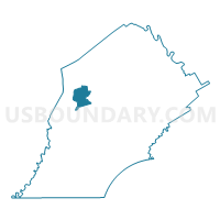
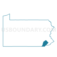
WEST CALN TWP PCT 01, Chester County, Pennsylvania
About
Outline

Summary
| Unique Area Identifier | 658490 |
| Name | WEST CALN TWP PCT 01 |
| County | Chester County |
| State | Pennsylvania |
| Area (square miles) | 10.88 |
| Land Area (square miles) | 10.57 |
| Water Area (square miles) | 0.30 |
| % of Land Area | 97.23 |
| % of Water Area | 2.77 |
| Latitude of the Internal Point | 40.02418410 |
| Longtitude of the Internal Point | -75.85980480 |
Maps

Graphs
Select a template below for downloading or customizing gragh for WEST CALN TWP PCT 01, Chester County, Pennsylvania


Neighbors
Neighoring Voting District (by Name) Neighboring Voting District on the Map
- COATESVILLE WD 03, Chester County, PA
- HONEY BROOK TWP PCT 02, Chester County, PA
- SADSBURY TWP VTD NORTH, Chester County, PA
- VALLEY TWP PCT NORTH, Chester County, PA
- WEST BRANDYWINE TWP VTD WEST, Chester County, PA
- WEST CALN TWP PCT 02, Chester County, PA
Top 10 Neighboring County Subdivision (by Population) Neighboring County Subdivision on the Map
- Coatesville city, Chester County, PA (13,100)
- West Caln township, Chester County, PA (9,014)
- Honey Brook township, Chester County, PA (7,647)
- West Brandywine township, Chester County, PA (7,394)
- Valley township, Chester County, PA (6,794)
- Sadsbury township, Chester County, PA (3,570)
Top 10 Neighboring Place (by Population) Neighboring Place on the Map
Top 10 Neighboring Unified School District (by Population) Neighboring Unified School District on the Map
Top 10 Neighboring State Legislative District Lower Chamber (by Population) Neighboring State Legislative District Lower Chamber on the Map
- State House District 13, PA (77,777)
- State House District 26, PA (74,084)
- State House District 155, PA (71,402)
Top 10 Neighboring State Legislative District Upper Chamber (by Population) Neighboring State Legislative District Upper Chamber on the Map
- State Senate District 44, PA (288,673)
- State Senate District 9, PA (277,401)
- State Senate District 36, PA (275,192)
Top 10 Neighboring 111th Congressional District (by Population) Neighboring 111th Congressional District on the Map
Top 10 Neighboring Census Tract (by Population) Neighboring Census Tract on the Map
- Census Tract 3049, Chester County, PA (7,647)
- Census Tract 3053, Chester County, PA (6,796)
- Census Tract 3051.02, Chester County, PA (4,721)
- Census Tract 3051.01, Chester County, PA (4,293)
- Census Tract 3114.04, Chester County, PA (3,881)
- Census Tract 3073, Chester County, PA (3,570)
- Census Tract 3114.03, Chester County, PA (3,513)